Sequence of exploratory steps in the exploration of a new region
Nbsp; Oil exploration is the search by petroleum geologists for hydrocarbon deposits beneath the Earth's surface. Oil and gas exploration are grouped under the science of petroleum geology.
Exploration methods
Visible surface features such as oil seeps, natural gas seeps, pockmarks (underwater craters caused by escaping gas) provide basic evidence of hydrocarbon generation (be it shallow or deep in the Earth). However, most exploration depends on highly sophisticated technology to detect and determine the extent of these deposits. Areas thought to contain hydrocarbons are initially subjected to a gravity survey or magnetic survey to detect large scale features of the sub-surface geology. Features of interest (known as leads) are subjected to more detailed seismic surveys which work on the principle of the time it takes for reflected sound waves to travel through matter (rock) of varying densities and using the process of Depth conversion to create a profile of the substructure. Finally, when a prospect has been identified and evaluated and passes the oil company's selection criteria, an exploration well is drilled in an attempt to conclusively determine the presence or absence of oil or gas.
Oil exploration is an expensive, high-risk operation. Offshore and remote area exploration is generally only undertaken by very large corporations or national governments. Typical Shallow shelf oil wells (e.g. North sea) cost $10 - 30 Million, while deep water wells can cost up to $100 Million plus. Hundreds of smaller companies search for onshore hydrocarbon deposits worldwide, with some wells costing as little as $500,000 USD.
Elements of a petroleum prospect
A prospect is a potential trap which geologists believe may contain hydrocarbons. Five elements have to be present for a prospect to work and if any of them fail neither oil nor gas will be present.
- A source rock - When organic-rich rock such as oil shale or coal is subjected to high pressure and temperature over an extended period of time, hydrocarbons form.
- Migration - The Hydrocarbons are expelled from source rock by three density-related mechanisms: the newly-matured hydrocarbons are less dense than their precursors, which causes overpressure; the hydrocarbons are lighter medium, and so migrate upwards due to buoyancy, and the fluids expand as further burial causes increased heating. Most hydrocarbons migrate to the surface as oil seeps, but some will get trapped.
- Trap - The hydrocarbons are buoyant and have to be trapped within a structural (e.g. Anticline, fault block) or stratigraphic trap
- Seal or cap Rock - The hydrocarbon trap has to be covered by an impermeable rock known as a seal or cap-rock in order to prevent hydrocarbons escaping to the surface
- Reservoir - The hydrocarbons are contained in a reservoir rock. This is a porous sandstone or limestone. The oil collects in the pores within the rock. The reservoir must also be permeable so that the hydrocarbons will flow to surface during production.
Terms used in petroleum evaluation
|
|
|
- Lead- a structure which may contain hydrocarbons
- Prospect - a lead which has been fully evaluated and is ready to drill
- Chance of Success - An estimate of the chance of all the elements (see above) within a prospect working, described as a probability. High risk prospects have a less than 10% chance of working, medium risk prospects 10-20%, low risk prospects over 20%. Typically about 40% of wells recently drilled find commercial hydrocarbons.
- Hydrocarbon in Place - amount of hydrocarbon likely to be contained in the prospect. This is calculated using the volumetric equation - GRV x N/G x Porosity x Sh x FVF
- GRV - Gross Rock volume - amount of rock in the trap above the hydrocarbon water contact
- N/G - net/gross ratio - percentage of the GRV formed by the reservoir rock ( range is 0 to 1)
- Porosity - percentage of the net reservoir rock occupied by pores (typically 5-35%)
- Sh - hydrocarbon saturation - some of the pore space is filled with water - this must be discounted
- FVF - formation volume factor - oil shrinks and gas expand when brought to the surface. The FVF converts volumes at reservoir conditions (high pressure and high temperature) to storage and sale conditions
- Recoverable hydrocarbons - amount of hydrocarbon likely to be recovered during production. This is typically 10-50% in an oil field and 50-80% in a gas field.
Licensing
Petroleum resources are typically owned by the government of the host country. The government issues licences to explore, develop and produce its oil and gas resources, which are typically administered by the oil ministry. There are several different types of licence. Typically oil companies operate in joint ventures to spread the risk, one of the companies in the partnership is designated the operator who actually supervises the work.
|
|
|
- Tax and Royalty - Companies would pay a royalty on any oil produced, together with a profits tax (which can have expenditure offset against it). In some cases there are also various bonuses and ground rents (license fees) payable to the government - for example a signature bonus payable at the start of the licence. Licences are awarded in competitive bid rounds on the basis of either the size of the work programme (number of wells, seismic etc) or size of the signature bonus.
· Production Sharing contract (PSA) - A PSA is more complex than a Tax/Royalty system - The companies bid on the percentage of the production that the host government receives (this may be variable with the oil price), There is often also participation by the Government owned National Oil Company (NOC). There are also various bonuses to be paid. Development expenditure is offset against production revenue.
- Service contract - This is when an oil company acts as a contractor for the host government, being paid to produce the hydrocarbons.

Oil field
An oil field is a region with an abundance of oil wells extracting petroleum (oil) from below ground. Because the oil reservoirs typically extend over a large area, possibly several hundred kilometres across, full exploitation entails multiple wells scattered across the area. In addition, there may be exploratory wells probing the edges, pipelines to transport the oil elsewhere, and support facilities.
Because an oil field may be remote from civilization, establishing a field is often an extremely complicated exercise in logistics. For instance, workers have to work there for months or years and require housing. In turn, housing and equipment require electricity and water. Pipelines in cold areas may need to be heated. Excess natural gas needs to be burned off if there is no way to make use of it, requiring a furnace and stacks, and pipes to carry it from well to furnace.
|
|
|
Thus, the typical oil field resembles a small self-contained city in the midst of a landscape dotted with drilling rigs and/or the pump jacks known as "nodding donkeys" because of their bobbing arm. Several companies, such as BJ Services, Bechtel, Esso, Schlumberger Limited, Baker Hughes and Halliburton, have organizations that specialize in the large-scale construction of the infrastructure and providing specialized services required to operate a field profitably.
More than 40,000 oil fields are scattered around the globe, on land and offshore. The largest are the Ghawar Field in Saudi Arabia and the Burgan Field in Kuwait, with more than 60 billion barrels (10 km³) estimated in each. Most oil fields are much smaller. According to the US Department of Energy (Energy Information Administration), as of 2003 the US alone had over 30,000 oil fields.
In the modern age, the location of oil fields with proven oil reserves is a key underlying factor in many geopolitical conflicts. The term oilfield is also used as shorthand to refer to the entire petroleum industry.
Sequence of exploratory steps in the exploration of a new region
1. Investigative phase : identification of a sedimentary basin, type of a basin, surface evidence of hydrocarbons.
Step 1 - identification of a sedimentary basin. Travellers’ records, geologic literature (including simple topographic maps) and air photographs are the first materials searched for leads.
Step 2 - initial interpretation of the type of basin identified, as different basin types have different orders of expectation of hydrocarbon incidence.
Step 3 - most important single factor required for the basin to have become petroliferous is its stratigraphy. During this phase of the investigation, the geologists must always remember that no region should be written off, as unprospective, on the basis of its visible surface stratigraphy alone.
Step 4 - surface evidences of hydrocarbons (seepages, mud volcanoes, burnt clays, etc.).
Step 5 - paleontologic data(both ages and types of fossils are valuable as are their abundance and variety).
|
|
|
Step 6 - structural setting (areal relation between the basin and the principal outcrop belt; basin relation to the present continental shelf ).
Step 7 - logistic and quantitative consideration (tax, royalty, labor conditions).
2. Reconnaissance phase: localization of favorable stratigraphic trends, resource of a basin.
Step 1 - primary objective in this second phase is the localization of favorable stratigraphic trends, called plays. This process begins with a more detailed photo-geologic reconnaissance for regional control.
Step 2 - more through understanding of the regional stratigraphy and of the configuration of the strata within it. (reconnaissance seismic profiles – to identify the positions of reflecting horizons, possible unconformities and general high and low areas).This phase should lead to a decision on what will initially be regarded as basement for the drillers, its approximate depth.
Step 3 - structural style (detectable structures compressional or extensional, high or low in amplitude).
Step 4 - check the initial stratigraphic and structural interpretations, including those derived from reconnaissance seismic data by drilling stratigraphic tests at low-cost locations. The purpose is to verify the stratigraphy and identify potential source and reservoir horizons.
Step 5 - test-well samples, cores and logs study all horizons, offering source or reservoir potential or materials capable of accurate dating.
3. Economic phase: prospects
The single objective in this phase is the identification of drillable structures, called prospects. Structure becomes of prior concern over stratigraphy. Seismic study is now localized and intensified over areas revealed during the reconnaissance phase. Initial exploratory drillsites are selected; target horizons are chosen and drilling depths planned accordingly. The duration and costs of drilling are estimated.
4. Consolidation phase: assembly of crucial information about the concerning basin.
At this stage of exploration, crucial information concerning the basin in which they are operating is assembled. The information is summarized in a format suitable for poster or viewgraph display. The following items are suggested for inclusion once production has been established:
· Name and location of basin and its type;
· Nature of the basin’s boundaries;
· Ages of inception and termination of the basin (correlatable deformations);
· Intervening deformations (significant uncomformities);
· Age and nature of economic basement;
· Thickness(es) of sedimentary rocks (in basin center; along its margins);
· Estimated volume of sedimentary rocks;
· Maximum depth of deposition and formation representing it;
· Geothermal gradient;
· Most favored source rocks and their maturation values;
· Most favored reservoir rocks and their depths;
· Most favored trap types and time of their creation;
· Probable directions and times of migration;
· Period(s) of maximum pooling;
· Hydrodynamic characteristics;
· Probable distribution of fields;
· Additional observations, references.
The summary should be accompanied by a single prospect map and a single correlation chart for display purposes. Large companies have standardized their evaluation formats for each type of prospective basin; a number of versions have been published. Once a region is shown to be commercially petroliferous, exploration and development proceed concurrently. There are the following immediate tasks to be established:
1. probable limits of the basin in which oil and gas are likely to occur;
2. controls of their occurrence: the most probable source sediments, the most favored migration paths, the critical aspects of the structural style, the influence of particular facies changes or particular levels of truncation of the strata;
3. establish working procedures to order to receive and evaluate new data on this area.
The basic tools of exploration in exploring, maturing areas – maps, well logs, cross-sections and seismic records. Maps show structure contours on every correlatable stratigraphic horizon and isopach contours for every stratigraphic interval. Well logs –data of formation tops, thicknesses, uncomformities, gaps. Cross-sections derived from the logs and the maps and combined into fence diagrams, which reveal accurately the configurations of formation contacts, uncomformities, subcrops, etc.
 Petrophysics
Petrophysics (petro is Latin for "rock" and physics is the study of nature) is the study of the physical and chemical properties that describe the occurrence and behavior of rocks, soils and fluids. Petrophysics mainly studies reservoirs of resources, including ore deposits and oil or natural gas reservoirs. "Petrophysics is the study of the physical and chemical properties that describe the occurrence & behavior of rocks, soil and fluids." How well the occurrence & behavior of the physical & chemical properties and processes in rocks, soils & fluids are understood determines how well resources are developed.
While most petrophysicists work in the oil and gas industry, some also work in the mining and water resource industries. The properties measured or computed fall into three broad categories: conventional petrophysical properties, rock mechanical properties, and ore quality.
Conventional Petrophysical Properties Most petrophysicists are employed to compute what are commonly called conventional (or reservoir) petrophysical properties. These are: Porosity: amount of pore (or fluid occupied) space in the rock. Water Saturation: fraction of the pore space occupied by water. Permeability (fluid): quantity of fluid (usually hydrocarbon) that can flow from the rock as a function of time and pressure. Thicknessof rock with enough permeability to deliver fluids to a well bore. This property is often called “Net reservoir rock.” In the oil and gas industry, another quantity “Net Pay” is computed which is the thickness of rock that can deliver hydrocarbons to the well bore at a profitable rate. These measurements and computed properties are used to compute the amount of oil or gas present in a well bore and the rate at which that hydrocarbon can be produced to the Earth’s surface. In the water resource industry, the values are used to compute how much water can be produced to the surface.
Reservoir petrophysics, or the study of the physical properties of certain rock types, concerns itself with the measurement of field data from a well or wells, the processing of that data, its incorporation into physical models that describe the rock in place and field-wide, the calculation and interpretation of certain reservoir properties and finally the integration of these interpreted properties with others from cores (Sidewall and Conventional Whole Cores), tests and actual production to petrologically describe the reservoir in place and field wide.
None of the above can be measured directly. They are measure in conjunction with some other parameters. For example injection of an electric current and measurement of voltage response. Ohm's law relates the ratio of voltage to current as electrical resistance, which is multiplied by geometric factor become the material property called electrical resistivity. Electrical resistivity is the property that describes the ability if a material to support the process of charge transport. Archie's law describes the relationship b/w electrical resistivity and porosity, fluid saturation, cementation of the rock etc. Thus the injection of current & measurement of voltage can result in determination of porosity, fluid saturation and other parameters. However geometric factors in Archie's law have many built-in assumptions. These include considerations of rugosity of the borehole wall, wettability of the rock, presence or absence of clay minerals & more. Depending upon the choices made about these assumptions, different interpretations result for porosity, saturation & types of fluids. In petroleum reservoir evaluation, these have significant impacts & consequences for the extraction of oil.

RESERVOIR ROCK PROPERTIES
HYDROCARBON TRAPS
Hydrocarbon traps may be illustrated by considering a porous (пористый) permeable (проницаемый) formation that hаs been folded into an anticlinal trap by diatrophism (тектоническое воздействие) and is enclosed between impermeable (непроницаемый) rocks [Fig. 1].
|
|
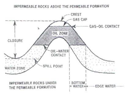
Fig.1 Idealized cross-section through an anticlinal trap formed by a porous, permeable formation surrounded by impermeable rocks. Oil and gas are trapped at the top of the anticline.
The closure (купол \ замыкание) of the trap is the distance between the crest (антиклинальный перегиб) and the spill point (lowest point of the trap that can contain hydrocarbons). In most cases, the hydrocarbon trap is not filled to the spill point. It may contain a gas cap (газовая шапка) if the oil contains light hydrocarbons and the pressure-temperature relationship of the zone permits the existence of a distinct gas zone at the top of the reservoir. If a gas cap exists, the gas-oil contact (газонефтяной контакт) is the deepest level of producible gas. Likewise, the oil-water contact (воднонефтяной контакт) is the lowest level of producible oil (нефтеотдача). Transition zones (переходная зона) exist between various zones grading from high oil saturation (нефтенасыщенность) to hydrocarbon-free water. For example, the water zone immediately below the oil-water contact is the bottom water (подошвенная вода), whereas the edge water (краевая \контурная вода) is laterally adjacent to the oil zone. The gas-oil and water-oil contacts are generally planar, but they may be tilted due to hydrodynamic flow of fluids, a large permeability contrast between opposite sides of the reservoir, or unequal production of the reservoir.
Дата добавления: 2019-01-14; просмотров: 371; Мы поможем в написании вашей работы! |

Мы поможем в написании ваших работ!