Fig. Desired and recorded seismic data
Desired information Geophones
Energy source
|
|

| Reflecting horizon |
Recorded information
Air wave Energy source Traffic noise
Geophones
|
|

Ground roll
Diffraction waves
Fig. Desired and recorded seismic data
Multiples
Reflecting horizon
| normal movement (NMO) | нормальное приращение (годографа отраженной волны) |
| offset | дистанция (расстояние от пункта взрыва до центра ближайшей группы сейсмоприемников) |
| p-waves | продольная волна |
| noise pattern | рисунок шумы |
| (low) frequency | частота |
| velocity | скорость |
| air wave | воздушная волна |
| multiple | многократно |
| interface | граница раздела двух сред (поверхность контакта) |
| intrabed | внутри |
Elements of a data acquisition system are:
1. Sources and arrays;
2. Detectors and arrays;
3. Instrumentation;
4. Field geometry or survey configuration.
 Profile
AIR GUN
four-gun array
Vibroseis
Five-vibrator array
SHOT HOLE
Surface


 Fig. Source arrays
Surveying, positioning and navigation there are a number of types of 1.seismic sources used in exploration. They fall within one of the two principal categories:
- impulsive (explosives);
- distributed or diffuse in nature (vibrators).
Seismic detectors
A variety of receiver types are available for detecting seismic waves. On land we use geophones, which respond to either vertical displacement or rotational motion. Vertical – displacement geophones are commonly used in land seismic data acquisition. They measure the rate of change of displacement or velocity In fact, they can measure derivative of displacement which is acceleration.
|
|
|
Multiple receivers can be connected in arrays to enhance the signal and to reduce noise. Types of arrays used include:
- linear array – a line of single geophones;
- weighted \ tapered array – a line in which the number of geophones at each position varies so that the outer elements have the smallest number of geophones (less weight) and the center element has the greatest number of geophones (most weight). The change in number of geophones from position to position is the taper of the array.
- Instrumentation represent great advancement in the recording of seismic signals without loss of information and with the ability to recover field amplitudes.
- Amplifer – filter – recorder
- Alias filter ( assure us that our digital sampling is properly accomplished and that high-frequency noise components do not masquerade as contributions of lower frequency by aliasing: is a property of sampling systems in which an input signal of one frequency can yield the same values as a signal of another frequency)
Alias filter frequency = 0.6 alias frequency
72 dB + amplitude
Discrimination from 0.6 FA – 1.0 FA
· Digitizer ( converts the analog electrical signals from the geophones into discrete samples)
· Gain ranging and control
· Sample –and-hold aperture ( in order to accomplish such conversion; it is necessary to hold a short portion of the analog signal for conversion to the digital equivalent)
- Field geometry – common depth point (CDP) gather is a group of seismic traces that represent a single point on a flat reflector. A common midpoint (CMP) gather is a group of traces from a dipping reflector. The traces of a common depth point (common midpoint) gather are put together in one family. Each trace is from a different source and different receiver, but represent the same subsurface point. This reordering of the traces and stacking (summing them together) enhances the signal- to-ratio by attenuating random effects and undesired events, such multiple reflections whose variation with offset offers from that of the primary reflections.
|
|
|
The diagram illustrates the ray path geometry for six shots taken and twelve geophones in the line.
By progressively moving the sources and the receivers, traces are obtained for a given subsurface point. These traces use different sources and receivers. The number of traces obtained for a common depth point is called the fold. At surface location R4, you can observe that the common depth subsurface point does have six traces. This type of shooting pattern is called end-on. If the TRACE 1 is the closest to the source, the shooting configuration is called pushing the cable. If TRACE 1 is the farthest from the source it is called pulling the cable. Another type of shooting pattern is split spread or straddle shooting, in which the source is in the middle, the middle spread is symmetrically split and the two banks of the spread are the same length. A technique called shooting through the cable may be used to place depth points as close to the line termination as possible.
|
|

| ни ma |
| юптнт or fwmmmio*. |
| 12 CHANNELS USED FOR SIMPLICITY. |
| (HIIURMCE СПСЯМС Mil » « Г . |
| « мшим raut • |
| END - ОМ POTTERN |
| » roi » » i » eie |
SOURCE
HI Я 2 R3 R*
Rn * RECEIVERS
"
Fig. Common depth point field geometry
1 1 1 1 1 1 1 1 1 1 1 1
| Seismic acquisition | Регистрация сейсмических волн |
| Seismic sources (impulsive \ distributed or diffuse) | Сейсмический источник (источник сейсмических сигналов) |
| Seismic detectors | Сейсмический детектор |
| Geophones | сейсмоприемник |
| Vertical displacement | Вертикальное перемещение |
| Rotational motion | Ротационное движение |
| Acceleration | Ускорение |
| Array | Расстановка (группа сейсмических соединенных каналов \ группа одновременно) |
| Linear array | Линейная группа |
| Weighted \ tapered array | Неоднородная группа \ источников с различными весами составляющих элементов) |
| Taper | Труба с раструбом |
| Instrumentation | Контрольно-измерительные приборы |
| Amplifer-filter-recorder | Амплитуда-фильтр |
| Alias (filter) | Неоднозначность частотного состава колебания восстанавливаемого по дискретным данным |
| Aliasing | Появление зеркальных частот |
| Digitizer | Цифровая форма |
| Gain (ranging and control) | увеличение |
| Sample-and-hold aperture | Отверстие \ апертура |
| Gather | Выборка записей (компоновка) |
| Shooting pattern: 1. end-on 2. pushing the cable 3. pulling the cable 4. straddle | Сейсмическая разведка с групповой взрыв (при расположении зарядов в геометрическом порядке) Фланговая сейсмическая расстановка |
| Shooting through the cable |
|
|
|
Seismic data processing
Data processing is a very powerful tool in manipulating the field information. It converts the raw data with all information, including noise and distorted information, to meaningful seismic cross-sections that represent vertical slices through the subsurface. These slices represent geological information and potential hydrocarbon traps.
A typical land data processing sequence may include:
- STAGE 1 –
- Field tapes
- Data reduction – dumultiplex and cross correlation
- Line geometry
- Prepare prestack analysis
- Decon, filter analysis, special problem tests
- STAGE 2 –
· Common depth sort (gather)
· Prestack filter or decon applications if needed
|
|
|
· Special enhancement to improve signal-to-noise (if needed)
· Application of elevation statistics
- STAGE 3 –
· Velocity analysis
· Velocity spectra-constant velocity stack
· Design of front-end mute
- STAGE 4 –
· Velocity applications
· Normal movement check
- STAGE 5 –
· Correlation statistics
· Surface-consistent residual statistics
· Application of statistics to sort
· Re-run velocity analysis with refined statistics
· Refined surface-consistent residual statistics
- STAGE 6 –
· Final stack
· Post-stack, filter and decon tests
· Post-stack enhancement programs
· Migration
· Seismic inversion
· Special post-stack applications
Data processing is both art and science. The processing steps should be handled on logic order. Every step should be checked carefully before proceeding to the next steps.
Migration
Dip migration (migration) is the process of moving the reflections to their proper places with their correct amount of dips.
In the case of a horizontal reflector the Earth models the same as the record section (a). In the case of a dipping reflector, the record section differs from the Earth model (b).
 | 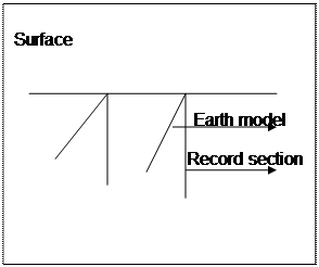 |
(a) Horizontal reflector (b) Dipping reflector
S: source; R: receiver
The above diagram shows the simple model of a flat reflector. Energy from the source goes straight down to the reflecting horizon and back up to a geophone at the shot point. If the horizon dips, the energy goes to and from it by the most direct path, which is along a normal to the reflector. Energy that strikes the reflector at other angles goes off in another direction.
The normal incidence principle is the basic behind dip migration. All migration techniques follow this principle. Structure and velocities cause the ray-path to follow a non-straight path down to the horizon to it. The reflection point is not applying normal move out corrections, the source and the receiver are in the same location. This section is called “zero offset section”, and the ray- path is perpendicular to the dipping reflecting horizons. We display the traces vertically and parallel, because they are only measurements of the times for a sequence of energy that strike the geophones. At this point, the time during which the ray traveled to and from a dipping reflector appears on the section as though the path had been straight down.
 |
It shows the normal incidence principle applied to the record section to convert to Earth model. Using the normal incidence principle, we can discuss some subsurface features and how they look when converted from the record section to the Earth model.
Induced polarization method
IP is a geophysical imaging technique used to identify subsurface materials, such as ore. The method is similar to electrical resistivity tomography, in that an electric current is induced into the subsurface through two electrodes, and voltage is monitored through two other electrodes.
Time domain IP methods measure the voltage decay or chargeability over a specified time interval after the induced voltage is removed. The integrated voltage is used as the measurement.
Frequency domain IP methods use alternating currents (AC) to induce electric charges in the subsurface, and the apparent resistivity is measured at different AC frequencies.
Дата добавления: 2019-01-14; просмотров: 194; Мы поможем в написании вашей работы! |

Мы поможем в написании ваших работ!